


UTM MGRS Map
Description of UTM MGRS Map
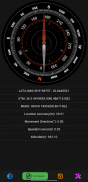
UTM MGRS Map is an application designed for outdoor enthusiasts and professionals who require precise navigation and mapping capabilities. It is available for the Android platform, making it accessible for users looking to download an effective tool for off-road activities. This app offers a variety of features that cater to various mapping needs, including support for multiple coordinate types such as UTM (Universal Transverse Mercator), MGRS (Military Grid Reference System), and standard latitude and longitude formats.
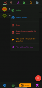
Users can engage in operation or activity planning, which is particularly useful for organizing trips or expeditions. The app facilitates the sharing of scheduled recordings, allowing users to collaborate and communicate effectively. In addition, it offers options to export and import scheduled recordings, ensuring that planning data can be easily transferred or shared among users.
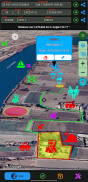
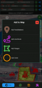
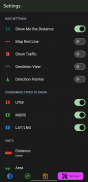
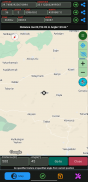
The application includes a compass feature that aids in navigation by providing directional information. Users can enhance their mapping experience by adding markers to the map, with options for customizing color, image, and size. This allows for easy identification of specific locations or points of interest. Designing lines and routes is another capability, enabling users to create personalized paths for their outdoor activities.
Creating designated areas on the map is straightforward, with options for frame and fill colors, allowing for visual differentiation of various zones. Users can also design circles on the map, similarly utilizing frame and fill color options to enhance visual representation. This flexibility in design helps users to adapt the mapping interface to their specific needs.
Automatic route recording creation is a feature that makes tracking movements easier. As users engage in their activities, the app can automatically document the paths taken, which can be valuable for reviewing journeys or planning future excursions. The app also supports progress tracking at specified distances and angles, providing users with real-time feedback on their movements.
Live location tracking is another significant feature, allowing users to see their current position on the map in real-time. This is particularly useful in remote areas where traditional navigation may be challenging. The app's ability to provide up-to-date location information enhances safety and confidence during outdoor ventures.
One of the advantages of UTM MGRS Map is its user-friendly interface, which is designed to be intuitive for both new and experienced users. The layout facilitates easy navigation through the various features and tools, ensuring that users can quickly access what they need without unnecessary complexity.
The app's mapping capabilities extend beyond basic navigation. Users can utilize various mapping layers and options, further enhancing their experience and providing more context to the data being viewed. This allows for a more comprehensive understanding of the surrounding environment.
With the ability to design routes and areas, the app supports a wide range of activities, from hiking and camping to more specialized tasks such as search and rescue operations. The flexibility in design and planning makes it a valuable tool for anyone engaged in outdoor activities that require precise navigation and mapping.
Markers can be customized not only by color but also by image, allowing users to visually represent different types of locations, such as campsites, water sources, or points of interest. This customization capability enhances the functionality of the mapping experience, making it more relevant to users' specific needs.
For users who often engage in group activities, the sharing of scheduled recordings becomes a vital feature. This allows for improved coordination and planning among multiple users, ensuring that everyone involved has access to the same information. The ability to import and export recordings further supports collaboration and data management.
The app's compass feature complements the mapping tools, providing directional guidance that is essential for outdoor navigation. This is particularly useful in areas with limited visibility or when exploring unfamiliar terrain, where traditional navigation methods may not be as effective.
In terms of technical performance, UTM MGRS Map is designed to operate efficiently on Android devices, ensuring that users can rely on its functionality even in challenging conditions. The app’s performance is optimized for outdoor use, making it suitable for a variety of environments and scenarios.
The integration of live tracking and automatic route recording enables users to document their adventures seamlessly. This feature is beneficial not only for personal records but also for sharing experiences with others, whether through reports or social media.
Overall, UTM MGRS Map is a robust application that combines advanced mapping features with user-friendly design. Its support for multiple coordinate systems, customizable markers, and live tracking capabilities makes it a versatile tool for outdoor activities. By offering efficient planning, recording, and sharing options, the app serves a wide audience, from casual hikers to professional navigators, ensuring that users can effectively manage their outdoor experiences.
UTM MGRS Map - Version 67
(25-03-2025)UTM MGRS Map - APK Information
APK Version: 67Package: com.apps.utmfinderLatest Version of UTM MGRS Map
Other versions


 3.79
3.79


Apps in the same category

You may also like...


